
In pictures: York flooding worst seen in 22 years
11 flood warnings have been issued across the city
York is facing the worse flooding seen in 22 years as a result of storms Eunice and Franklin.
The River Ouse is expected to peak this morning at nearly five meters with flooding across the city, closing roads and businesses. This would be the highest level since 2000 when the river reached 5.40m.
In total, 11 flood warnings have been put in place across the city. The Environment Agency says residents should avoid walking, cycling, or driving through flood water.

York council has reassured residents that all necessary defenses are in place including sandbags, water pumps, and bridges.
Councillor Paula Widdowson, executive member for climate change, said: “Frontline teams are immediately putting in place the local and citywide flood defences, so any resident or business at risk of flooding should also put their own flood plans in place. Sandbags will be provided to communities at immediate risk of flooding – so there is no need to contact us.”

Cars have been stranded in the floods
She continued: “We’re also asking people to check in on their neighbours and friends, if safe to do so. The Council are contacting vulnerable residents who are receiving care services in affected areas, to ensure they are aware of the support and services available to them. We ask that all residents take care, whilst on essential journeys and daily exercise, to avoid flooded area such as riverside paths and cycle ways.”

Emergency accommodation has been offered by the council amid fears that over 140 homes could be flooded. This emergency accommodation can be accessed at any time by calling 01904 551550.

Popular student pub, The Lowther, pumping water out of the building
Although most of the city is unaffected by the floodwater, riverside houses and businesses have been seriously damaged. Several businesses, including riverside pubs such as The Lowther and The King’s Arms, have been forced to shut.

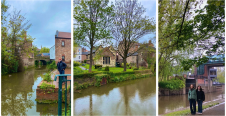
Flooding has risen up the streets
The council said that although St George’s Field and Esplanade car parks are closed due to flooding, “York is very much open fur business and your enjoyment.”

The riverside car park is completely underwater
A spokesperson for the Environment Agency told York Mix: “We know the devastating impact that flooding can have, which is why protecting people and communities is our top priority. Water levels in the upper catchments are going down and the picture is improving in these areas. The river level in Tadcaster has now peaked.”

They continued: “Although predictions can change as the forecasting model updates, we expect the Ouse to be at its highest level mid-morning on Tuesday. We have now issued all planned flood warnings and don’t anticipate that we will need to issue any further warnings at this stage.
“People should remain vigilant and take extreme care. We encourage people to check their flood risk online and keep up to date, follow @EnvAgency on Twitter for the latest updates or call Floodline on 0345 988 1188.”


This morning, river levels have peaked higher than the 2015 height when flooding caused mass destruction across the city. The river reached 5.40m on 4 November 2000, the highest level recorded, making the current floods the second highest on record.

Flood defences are in place across the city
Flood defences are in place across the city. Sandbags and pumps can be seen at the entrance to Tower Gardens by Clifford’s Tower. The pumps and sandbags can help prevent flooding up to an Ouse height of 4.8 metres.

Flooding at Millenium Bridge
For video footage of the flooding, head to our Instagram story @theyorktab
Related stories recommended by this writer:
• Uni of York scheme ‘YORCUP’ has saved over a million single use plastic cups from going to landfill
• A York student is running the London Marathon after girlfriend diagnosed with cancer
• Police appeal for information after part of man’s ear was bitten off at Kuda in York

Roses 2024 is back this weekend: Here’s a short history of the tournament
Lets hope it doesn’t end like the actual ‘War of Roses’ did
‘Fix the Foss’: Campaign launched by Uni of York students in the Environment Department
The campaign aims to increase the profile of the river and the state of its health

Applications to join The York Tab’s editorial team are now OPEN!
The deadline for applications is Wednesday 8th May
Lazy planning: We asked ChatGPT to plan the perfect day out for a student in York
The perfect way to pretend to be a tourist in York for a day

Review: University of York theatre students showcase political theatre performances
A totally unbiased review of these sold-out shows

This is exactly which Formula 1 team every University of York college would be
How about swapping your college colours for Ferrari red?
I tried and ranked five of the best study methods as a York student so you don’t have to
Academic comeback pending…
York PhD student’s research into ‘trans archeology’ called a ‘scam’ by conservative MP
Tory MP Nick Fletcher has called for a review of how taxpayer funds are used for higher education

York University staff and students campaign for donations for former student trapped in Gaza
The campaign has encouraged 200 more GoFundMe donations for Fadi Hania

Meet the new team of Students’ Union Sabbatical Officers at the University of York
Here are York’s officers for 2024-25

Indie Tuesday vs Tuesday Indie: An in-depth analysis of York indie student nights
Meet York’s answer to Blur vs Oasis

Man in York arrested at gunpoint for possession of class A drug and making ‘threats to kill’
A 32-year-old man was arrested on Wellington Street and later released on conditional bail

University of York apologises for using controversial symbol on World Autism Awareness Day
The Tweet using the controversial puzzle symbol has since been deleted

University of York accused of censoring student’s Hong Kong protest during graduation
The graduation livestream cut footage of a 27-year-old student who crossed the stage presenting a pro-Hong Kong flag

University of York announces implementation of latest Real Living Wage rate to staff
Staff in grade one will receive a wage increase of 0.004 pence per hour

YUSU The Lounge to be renamed ‘Long Boi’s Lounge’ with Greg James hosting official opening
Long Boi’s Lounge will open exactly one year on from the famous duck’s tragic passing
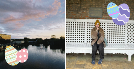
The official best places to hide an Easter egg on the University of York campus
Want to see your friends struggle? Bury one in an abandoned sack of circuit laundry

Here are all the best places to romanticise spring as a student in York
You can thank me later for these hidden gems, preferably with hot cross bun flavoured tea

Here’s a definitive guide to the best places to have pres as a York student
Because York nightlife is definitely not ‘dead’

‘Armistice now’: Pro-Palestine protestors gathered in York calling for ceasefire in Gaza
Students and staff from the University of York marched from St Helen’s Square on Saturday 16th March
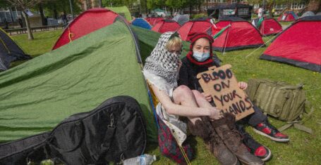
All the large-scale encampments happening at UK university campuses right now
The protestors plan to stay ‘indefinitely’ or until their demands are met

Richard Gadd has revealed which ‘disturbing’ Baby Reindeer scene was the most truthful
The scene was incredibly harrowing

The most terrifying episodes of Buffy that prove it used to be the scariest show on TV
Get that skin eating monster away from me
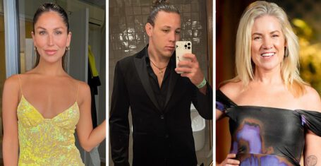
Ranked: Who from MAFS Australia 2024 gained the most Instagram followers on the show
This is what they really came for

Tim completely ‘cut off’ from media opportunities by MAFS producers after breaking contract
Executives of the show were ‘furious’ with Tim

Deleted scenes and alternate scripts: The biggest production secrets from Baby Reindeer
There’s a lot of truth being revealed

So after all the drama, who from MAFS Australia 2024 is actually still mates?
Lucinda is a common feature, of course

All the shows with 100 per cent Rotten Tomatoes ratings you need to watch after Baby Reindeer
Binged the entirety of Baby Reindeer in one day? I’ve got more for you


A release day ranking of Dua Lipa’s disappointing new album Radical Optimism
Inspired by Britpop and 90s rave culture? Where?

Baby Reindeer creator Richard Gadd is a secret millionaire raking in even more from Netflix
Umm, he has a whole other name he makes money under?
Richard Gadd reveals the reason why he banned his parents from watching Baby Reindeer
It’s absolutely heartbreaking

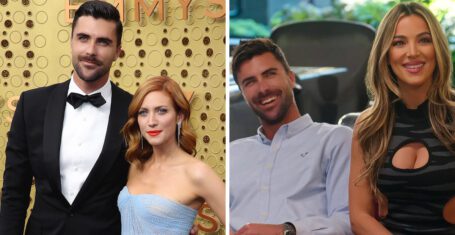
A rundown of all the drama between Selling The OC’s Tyler and Alex Hall and Brittany Snow
Brittany hinted Tyler was unfaithful during their marriage but Alex has snapped back

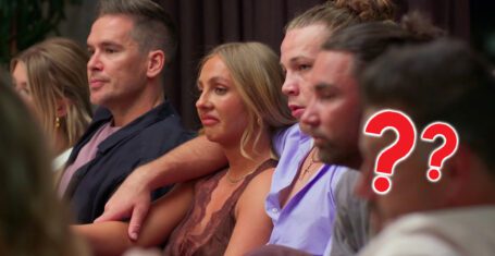
Every time the outspoken MAFS Australia 2024 cast savagely slammed the show’s producers
They have not held back at all

Ranking The Real Housewives cast by the whopping amount they’ve spent on plastic surgery
I’ve never felt so poor


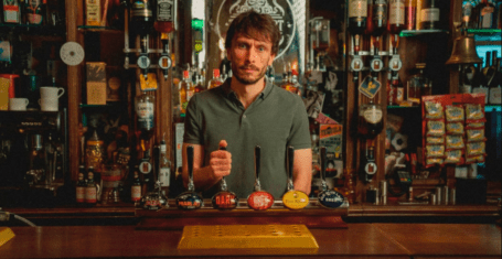
Camden pubs to comedy clubs: All of the real-life locations used for filming Baby Reindeer
Probably best to avoid some of these locations
Three MAFS Australia 2024 cast members wanted to quit but stayed until the end of the show
Producers persuaded some to stay whilst others have said they still regret not leaving
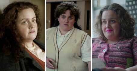
Here’s where to watch Jess Gunning next if you loved her in Netflix’s Baby Reindeer
She has ironically played many police officers

You need to watch the explosive new dating show Love Triangle that makes MAFS look tame
It’s got dinner parties, arguments and cheating scandals in the first two episodes!