

Bleak Map Shows What London Will Look Like During The Tube Strikes
Strike map makes London look empty
In case you didn’t already know, there will be two 48-hour strikes on The Tube in London over the next two weeks. The first will begin 9:30 tonight until Thursday evening.
A London-based blogger has developed a nightmarish map representing which lines will run during the planned Tube strike beginning this evening.
Ian Mansfield created the map to show the disrupted service for Londoners over the next two days, leaving large swathes of central London empty (click for larger version):
28 Days…now? (click for larger version)
Unfortunately for UCL students, it means no Northern line to Goodge or Warren Street, and no trains to Euston or Russell Squares, with buses are likely to be rammed in order to compensate.
Kings students will have to make the extra schlep to Embankment. If you’re at Imperial: the Piccadilly line in central London and Circle/District in from Notting Hill and Paddington will be down meaning that the District will be the only way to get to South Kensington although public transport to the West London clinical sites from Hammersmith should be unaffected.
Tube staff belonging to the RMT and TSSA unions are set to walk out in protest against measure to shut ticket offices by 2015.
With even lecturers having trouble getting in over the strike, the Tab strongly advises you stay in bed.

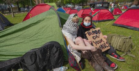
UCL students set up encampment on campus in solidarity with Palestine
Tents were pitched last night, with students intending to stay until their demands are met

The London Tab needs you: Apply to be a part of the 2024-2025 editorial team now
Applications close on Saturday 4th May

London University student killed alongside friends after ‘doing high-speed laps’ in car park
20-year-old Sohail Zulfiqar died after the convertible crashed down an embankment

Apparently all London universities have mottos and some of them are… questionable
Imperial’s motto did NOT pass the vibe check

Eight tips for students going abroad to study next year, from a UCL student survived it
The best time of your life is waiting for you, and you’re probably nervous – don’t be!

Mum of student who died from laughing gas calls on ministers to make it a Class A drug
Ellen Mercer died from a cardiorespiratory collapse in February 2023

A (brief) guide to the best and the worst of London student nightlife
Bad news – you might want to stay away from Ministry Tuesdays if you’re over the age of 20

Pregnant UCL alumna in Gaza sets up GoFundMe in order to evacuate and give birth safely
Yara told the The London Tab of the ‘disastrous’ conditions, with no access to medical care or electricity

UCL to rebrand as ‘The London University’ to distance itself from King’s College London
A leaked email explained that UCL’s name will change because it is too similar to KCL

‘Bright, brilliant and brave’ LSE student killed in bike collision with rubbish lorry
Cheistha Kochhar collided with a refuse truck last Tuesday and died at the scene

American Football Varsity match abandoned after King’s player allegedly used racial slur on pitch
A King’s student called a UCL Emperor’s player a ‘n****r’ during the game

Imperial College London academics found to be linked to Chinese military institutions
Researchers co-authored at least five studies with scientists linked to the Chinese People’s Army

Pro-Palestine protesters occupy a room at UCL and declare it an ‘Apartheid Free Zone’
Protestors occupied the Jeremy Bentham room on Friday and claim they will stay until their list of 10 demands are met

Over 1,000 people sign petition for independent review of LSE’s sexual misconduct procedure
LSE has been criticised for its ‘mishandled’ investigation into a professor facing 14 allegations of sexual misconduct

SOAS and Met Police criticised over search for missing student as body pulled from Thames
SOAS claimed it ‘immediately’ attempted to contact Samaria when students first raised concerns

LSE students interrupt lecture and call for ‘racist’ Israeli historian to be kicked off campus
Benny Morris said ‘I’d rather be a racist than a bore’ after students protested in his lecture last week

UCL lecturer banned from teaching course on China to protect uni’s ‘commercial interests’
The academic claims that universities are ‘conceding to the censorship demands of some Chinese students’

Corporate gone creative: A look inside LSE’s recent fashion show
Breaking news – LSE finance bros seen wearing something other than quarter-zips for the first time ever

Here’s which Taylor Swift album your London university is, based on pure vibes
Sorry, but we can’t all be 1989 (Taylor’s Version, of course)

Imperial student blackmailed by security guard over girlfriend living in halls with him
Dean Carter demanded the Imperial student pay him £2,400 for allegedly breaking accommodation rules
All the large-scale encampments happening at UK university campuses right now
The protestors plan to stay ‘indefinitely’ or until their demands are met

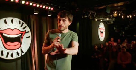
Richard Gadd has revealed which ‘disturbing’ Baby Reindeer scene was the most truthful
The scene was incredibly harrowing

The most terrifying episodes of Buffy that prove it used to be the scariest show on TV
Get that skin eating monster away from me
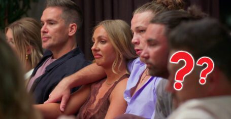
Ranked: Who from MAFS Australia 2024 gained the most Instagram followers on the show
This is what they really came for

Tim completely ‘cut off’ from media opportunities by MAFS producers after breaking contract
Executives of the show were ‘furious’ with Tim

Deleted scenes and alternate scripts: The biggest production secrets from Baby Reindeer
There’s a lot of truth being revealed

So after all the drama, who from MAFS Australia 2024 is actually still mates?
Lucinda is a common feature, of course
All the shows with 100 per cent Rotten Tomatoes ratings you need to watch after Baby Reindeer
Binged the entirety of Baby Reindeer in one day? I’ve got more for you


A release day ranking of Dua Lipa’s disappointing new album Radical Optimism
Inspired by Britpop and 90s rave culture? Where?

Baby Reindeer creator Richard Gadd is a secret millionaire raking in even more from Netflix
Umm, he has a whole other name he makes money under?
Richard Gadd reveals the reason why he banned his parents from watching Baby Reindeer
It’s absolutely heartbreaking

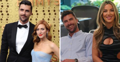
A rundown of all the drama between Selling The OC’s Tyler and Alex Hall and Brittany Snow
Brittany hinted Tyler was unfaithful during their marriage but Alex has snapped back

Every time the outspoken MAFS Australia 2024 cast savagely slammed the show’s producers
They have not held back at all

Ranking The Real Housewives cast by the whopping amount they’ve spent on plastic surgery
I’ve never felt so poor

Camden pubs to comedy clubs: All of the real-life locations used for filming Baby Reindeer
Probably best to avoid some of these locations
Three MAFS Australia 2024 cast members wanted to quit but stayed until the end of the show
Producers persuaded some to stay whilst others have said they still regret not leaving
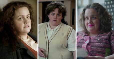
Here’s where to watch Jess Gunning next if you loved her in Netflix’s Baby Reindeer
She has ironically played many police officers

You need to watch the explosive new dating show Love Triangle that makes MAFS look tame
It’s got dinner parties, arguments and cheating scandals in the first two episodes!